I am an AI and create your individual experience - answer the following questions:
- Duration
- 17:20 h
- Distance
- 64.62 km
- Elevation gain
- 758 hm
Starting point: Jugetach/Trabers (between Missen and Stiefenhofen)
End point: Lindau, or Nonnenhorn
Missen - Stiefenhofen - Weiler - Scheidegg - Niederstaufen - Sigmarszell - Weißensberg - Lindau - Wasserburg - Nonnenhorn
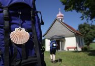
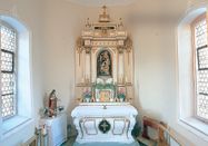
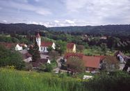
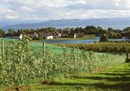
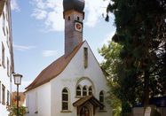
Jugetach/Trabers - Stiefenhofen/Genhofen - NagelshubComing from Weitnau and Missen-Geratsried, our pilgrimage path in the district of Lindau (Lake Constance) begins in the municipality of Stiefenhofen. We cross the Jugetach and reach the steep ascent, past "Abeles Alp," to the Alp "Rote Heide." On the small municipal road, it continues to the villages of Trabers and Mutten.At the exit of Mutten, we turn left to the Zell hiking trail over the "Schwarzenbachtal". The path continues past the Zell chapel, which lies within the Oberstaufen district, towards Weißenbachmühle. We cross the railway bridge and reach, via Wolfsried and past a riding stable, the village of Genhofen with the famous St. Stephen's chapel. Then we turn left onto the chapel path.Pass to the right of the sawmill to Aich, then left to Iringshofen. After the last farmstead, our path turns right through the valley floor to Hopfen to the St. Martin's chapel.The path continues past the dairy through the forest over Hinteregg to Burkatshofen. From here, the path leads back to the old salt road, where after about 1 km Nagelshub is reached.Pilgrim stamps:Guest Office Stiefenhofen, Hauptstraße 7Genhofen (St. Stephen's Chapel)Hopfen (St. Martin's Chapel)
Nagelshub - WeilerComing from Burkatshofen, we reach Nagelshub, where we follow the hiking trail R9/10 to the right. Shortly after, we turn left toward Simmerberg. In the town center near the Gasthof Krone, we proceed on Rieder Straße toward Weiler. We pass under the German Alpine Road and reach the town center of Weiler via Kapfmühle. Around the cemetery, St. Blasius church, and Hausbach, the Jakobus pilgrimage trail splits. We choose the route via Scheidegg, where you can find a pilgrim center with overnight accommodations. The second option continues via Lindenberg.
Weiler - ScheideggParallel to Hausbachstraße along the cemetery wall, we follow the Hausbach downstream past the Wendelins chapel. In Bremenried, we turn right into Scheidegger Straße. Shortly before leaving town, we leave the street to the left towards Altenburg.Pilgrim stamps:Gasthof Krone, Alte Salzstr. 50, SimmerbergParish Church St. Josef, SimmerbergAntonius Chapel, Rieder/SimmerbergCatholic Parish Office St. Blasius, Schulstr. 11, WeilerTourist Information, Hauptstr. 14, WeilerGasthof Engel, Kirchplatz 5, Weiler
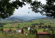
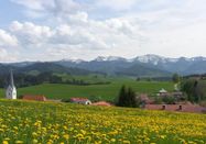
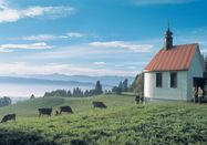
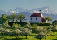
Altenburg - Scheidegg - AllmansriedComing from Weiler-Simmerberg, the path leads from Altenburg partly on the Kneipp circular hiking trail via Forstenhäuser to Böserscheidegg. Along the ecumenical chapel trail "Paths for Body and Soul," we walk towards Schalkenried (1 km) with a magnificent panoramic view of the Alps. In Ablers, we turn right uphill on Kurstraße, past the clinics, towards Scheidegg town center.From the town center/Scheidegg Tourism, we follow Bräuhausstraße towards Bieslings. From here, we continue to Gretenmühle and cross Alpine Road B 308. From Gretenmühle, the path leads further to Allmannsried. At the Rappenfluh farm, we reconnect with route 3 coming from Lindenberg.At Rappenfluh farm, the path leads into the forest. After 10 minutes, we see over the large meadow area down to the sparkling Lake Constance and the mighty Alpstein with the main peaks Säntis and Altmann. Before Lötz, we turn off to the Wendelins chapel. Then the path goes straight ahead to a farm named "Kinberg".Pilgrim stamps:Scheidegg Tourism, Rathausplatz 8Pilgrim center at the Protestant church, Am Hammerbach 14, Tel. 0151 54875791
Kinberg - Niederstaufen - Schlachters - Weißensberger Halde - StreitelsfingenAfter the farm named "Kinberg," we turn right towards the forest. In the forest, after 80 m, we go down a steep footpath to the left, which is secured with stairs. We reach a wide forest path, which we follow to the left. After 400 m, we reach a fork. Here we go right along a meadow. Steeply downhill, we reach the hamlet of Adelberg. On the paved road, we continue downhill. Shortly before Niederstaufen, we turn left into a small forest and then hike along the forest edge towards Niederstaufen church. We leave it to the left and walk along the Allgäustrasse to the right. Passing a grocery store, we reach the junction turning left towards the Leiblach stream.Here we come across the Leiblach hiking trail, which is also called "Leiblach-Uferweg" on a sign. We follow it downstream. We cross the stream on a narrow steel bridge. On the other bank, we follow a paved path uphill for 400 m, then turn left into the forest. On a romantic forest and meadow path, the Leiblach hiking trail leads us south. Later a narrow path leads back to the river. Here, a bridge leads over a creek at its confluence with the Leiblach. Now we reach a broader forest path, following the river course.
Path through a ravine and Sigmarszell(scenic but difficult)We now cross B 308 (a tunnel is planned soon) and follow the path straight to the houses of Dornach. Shortly after, we follow a right curve. We come to more houses in Dornach. Here we first go right. After 150 m, we turn left, following the Leiblach hiking trail markings, onto a narrow meadow path that leads us through a forest ravine with several stairs and a bridge to Sigmarszell. Note: the path through the ravine is not paved and dangerous when wet.We come directly to the church. From here, we turn right and follow the straight street uphill to Biesings. Before the ascent to B 308, we turn left and walk 300 m along the road until an underpass lets us through and we reach Schlachters.
Easier route along B308After crossing B 308, we now hike for 2 km on a bicycle/pedestrian path along B 308 to Biesings. We cross a side road until an underpass beneath B 308 lets us through and we reach Schlachters.
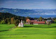
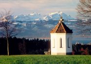
Continuing from SchlachtersWe follow the main street past the town hall, turn left just before the pharmacy into Weiherstraße. This road leads us into the forest past the sports field and Schlachter pond. On a bridge, we cross A 96 and immediately turn right onto a forest path. This bends left near the railway tracks. Here we turn left and hike slightly uphill to the Weißensberger Halde. This small ascent is rewarded with a wonderful view of Lake Constance and the Alps. At the free-standing chapel, a panoramic board helps us find the names and heights of the visible mountains. From the Halde, we descend a narrow footpath with a railing. Downhill, we reach a narrow, paved footpath, which we follow to the left. It merges into a connecting road, which we follow downhill to the right. At the next junction, we go left under B 308 and turn right at the fork towards Streitelsfingen. From this road, we turn right after 500 m and follow this path to Streitelsfingen.Pilgrim stamp:Town Hall Sigmarszell-Schlachters, Hauptstraße 28
Streitelsfingen - Lindau IslandIn Streitelsfingen, we walk past Montfort Castle on the street. After about 100 meters, we turn left onto a meadow path that leads us along the height through orchards. At the end of the meadow path, we descend right and reach Röntgenstraße, which we now follow. We arrive at a residential area. After passing the intersections Bäuerlinshalde, Bantingstraße, and Otto-Hahn-Straße, we turn right into a narrow meadow path. We follow this and turn right into Oberreutiner Weg, where the Jakobus Pilgrim Hostel is located. We leave the cemetery and St. Verena church to the left. The path leads us slightly downhill to the left, then, easy to miss, we turn left again into a narrow footpath, "das Gängle." Soon we reach Köchlinstraße, which we follow turning right. The street soon makes a sharp left curve. We continue straight past the savings bank until we reach Kemptener Straße, which we cross with great care. On the other side, we reach idyllic Köchlinweiher and Bleicheweg. Along a stream, we reach a nursery, which we leave on the right. Passing the building yard (left), we continue straight and cross Bleicheweg at the intersection with Privatweg. Past the savings bank building, we reach a pedestrian light to cross the busy Bregenzer Straße. After the light, we keep right and pass the railway barrier of the Lindau–Bregenz line, following Bregenzer Straße towards the island. After a bridge over the Ach, we turn left into the city administration area. At the car park, we walk to the lake. We follow the shore path to the right to the pier, which we cross. After the bridge, we immediately turn left and follow the shore path past the casino. After a boat landing stage, we continue by the lake and then turn right again at the end of the shore path to reach Fischergasse, which we follow a short distance past the "Old Post", turning left. A narrow passage marks the entrance to Gerberschanze on the left. From here, we follow the shore path again past the sailing harbor to the Lindau harbor.
Continuation from Lindau's pier further to WasserburgAfter visiting Lindau Island, we turn westward on the land side at the Lindau pier. First, we pass the mini-golf course along the lake. Then we follow Aeschacher Ufer to the railway barrier, which we cross. We continue straight on a combined pedestrian and bicycle path along the shore and then on Giebelbachstraße to Schachener Straße. Here, we turn left following the road and then again left after about 500 meters into Oeschländerweg. Soon, signs point left to Hotel Bad Schachen. Past this impressive hotel complex, the path leads to Lindenhofpark, which we cross for a bit along the lake. Past Lindenhofbad, we reach Lindenhofweg. In front of Schloss Alwind (rest home), we go left down to the lake again. After passing the manicured garden of this castle-like building near the shore, the path leads right up again to Uli-Wieland-Straße and soon to Reutener Straße.Pilgrim stamp:Tourist Information Lindau, Alfred-Nobel-Platz 1, opposite the main station
Wasserburg - Reutenen - NonnenhornComing from Lindau, we reach the Wasserburg town sign (district: Reutenen) on Uli-Wieland-Straße. We follow it to the junction with Reutener Straße. Here, on the right side, you can see the gable front of the small Jakobus chapel, which pilgrims should definitely visit. However, our path leads left through meadows to a wayside shrine, where we keep left on the unpaved hiking trail. It brings us back to Reutener Straße and past the outdoor facilities of the outdoor pool. Shortly after, we turn left again, clearly visible at the entrance to Sumser-Halle. We now cross a park-like area with a monument to "Lieber Augustin" on the lakeshore, a playground, and tennis courts. At the first houses, we reach Uferstraße. We follow it until it meets Halbinselstraße. We walk on this until a fork near Hotel "Zum Lieben Augustin." From here, the path leads left to the sights on the Wasserburg peninsula.We keep right, pass the restaurant "Hege Strand 3" and the mini-golf course and enter a poplar avenue. We stay on this path, reserved only for walkers and cyclists, near the shore, leave a nature reserve on the left behind, and soon see the Nonnenhorn town sign.Pilgrim stamp:Office of the St. Georg parish, outside these times on request at the pastor
NonnenhornComing from the Wasserburg peninsula, after the beautiful poplar avenue, we reach the Nonnenhorn town sign. At the fork, we keep left along the road by the lake and make a small detour to the "Malerwinkel," a public lake access from where we have a wonderful view again over the peninsula with Wasserburg Castle and St. Georg's church. Back on Wasserburg Straße, we follow it to about 1.5 km to the 400-year-old "Weintorkel" in Nonnenhorn town center, which is definitely worth seeing. From there, we turn left again toward the lake. The path leads us past the tourist information on the right side and the ferry landing on the left to the beach and after a right curve goes uphill for 150 m to the Weinstube Fürst. There we turn sharply right onto the historic chapel square and now stand before the entrance to the St. Jakobus chapel from the 14th century. To the right of its entrance is an overview board of the Jakobusweg in Bavarian Swabia. On the wall of the inn opposite the chapel, we discover an old pub sign with St. Jakobus.From Wasserburg or Lindau, it is now possible to take the ship to Rorschach and continue on the Swiss route to Einsiedeln. Please note the season April/May to about October: www.bsb-online.com . Also, there is the possibility to hike to Friedrichshafen and take the catamaran to Konstanz.Pilgrim stamps:Gasthaus Zur Kapelle, next to St. Jakobus Chapel, Tel. 08382-8274Tourist Information Nonnenhorn, Seehalde 2, Tel. 08382-8250Bruno Markowski, Im Gehren 6b, Tel. 08382-8085
The complete brochure with pilgrim-friendly accommodations can be downloaded at: https://www.westallgaeu.de/touren-jakobsweg
Your local tourist information offices:
Guest Office StiefenhofenHauptstraße 788167 StiefenhofenTel. 08383-7200, Fax 08383-921302gaesteamt@stiefenhofen.de, www.stiefenhofen.de
Guest Office GrünenbachTourism ArgentalHauptstr. 5088167 Grünenbach (Allgäu)Tel: 08383 / 9295924tourismus@vg-argental.de
Tourist Information Weiler-Simmerberg-EllhofenHauptstraße 1488171 Weiler im AllgäuTel. 08387-39150, Fax 08387-39153info@weiler-tourismus.de, www.weiler-tourismus.de
Tourist Information LindenbergStadtplatz 188161 LindenbergTel. 08381-80328, Fax 08381-80388touristinformation@lindenberg.de, www.lindenberg.de
Scheidegg TourismRathausplatz 888175 ScheideggTel.: 08381 89422-33, Fax: 08381 89422-30info@scheidegg.de, www.scheidegg.de
Town Hall Sigmarszell-SchlachtersHauptstraße 2888138 SigmarszellTel. 08389-920317, Fax 08389-920349gemeinde@sigmarszell.de, www.sigmarszell.de
Lindau Tourism and Marketing GmbHAlfred-Nobel-Platz 188131 Lindau (Lake Constance)Tel. 08382-8899900, Fax 08382-8899888info@lindau-tourismus.de, www.lindau.de
Tourist Information WasserburgLindenplatz 188142 Wasserburg (Lake Constance)Tel. 08382-887474, Fax. 08382-89042tourist-info@wasserburg-bodensee.de, www.wasserburg-bodensee.de
Tourist Information NonnenhornSeehalde 288149 NonnenhornTel. 08382-8250, Fax 08382-89076tourist-info@ti-nonnenhorn.de, www.nonnenhorn.de

Schlechtes Wetter?
Auch bei diesen Bedingungen gibt es viel zu entdecken! Wir haben einige Orte in der Nähe für Sie zusammengestellt, die Sie bei schlechtem Wetter gut besuchen können.
jetzt entdecken