I am an AI and create your individual experience - answer the following questions:
- Duration
- 17:50 h
- Distance
- 63.63 km
- Elevation gain
- 658 hm
Starting point: Jugetach/Trabers (between Missen and Stiefenhofen)
End point: Lindau, or Nonnenhorn
Missen - Stiefenhofen - Weiler - Lindenberg - Hof Rappenfluh - Niederstaufen - Sigmarszell - Weißensberg - Lindau - Wasserburg - Nonnenhorn
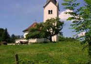
Jugetach/Trabers - NagelshubApproaching from Weitnau and Missen-Geratsried, our pilgrimage route in the Lindau district (Lake Constance) begins in the Stiefenhofen area. We cross the Jugetach and ascend steeply past “Abeles Alp” to the “Rote Heide” alpine pasture. On the small municipal road, it continues to the villages of Trabers and Mutten.At the exit of Mutten, we turn left onto the Zell hiking trail through the "Schwarzenbachtal". The path leads past the Zell chapel, located in Oberstaufen, towards Weißenbachmühle. We cross the railway bridge and reach Wolfsried, passing the riding stable, to the village of Genhofen with its famous St. Stephen's chapel. Then we turn left onto the chapel path.Right past the sawmill to Aich, then left to Iringshofen. After the last farmhouse, our way turns right through the valley floodplain to Hopfen to St. Martin's chapel.The path continues past the dairy through the forest via Hinteregg to Burkatshofen. From here, the route leads back to the old salt road, where after about 1 km we reach Nagelshub.Pilgrim stamps:Stiefenhofen Guest Office, Hauptstraße 7Genhofen (St. Stephen’s Chapel)Hopfen (St. Martin’s Chapel)
Nagelshub - Altenburg/Erratic BlockComing from Burkatshofen, we reach Nagelshub, where we follow the hiking trail R9/10 to the right. Shortly after, we turn left towards Simmerberg. In the village center by the Gasthof Krone, we take Rieder Straße towards Weiler. We pass under the German Alpine Road and reach the center of Weiler via Kapfmühle. Near the cemetery, St. Blasius church, and Hausbach, the Jakobus pilgrimage way splits. We choose the variant via Scheidegg, where you can find a pilgrim center with overnight accommodations. The second variant continues via Lindenberg.
Alternative: Continuing via Lindenberg (main route via Scheidegg)We follow Bahnhofstraße and Kristinusstraße to the junction with Eschweidstraße. There we turn left and after a few meters immediately right to join hiking trail R5. Over the Erratic Block (glacial erratic), we reach the Lindenberg district of Manzen.
Pilgrim stamps:Gasthof Krone, Alte Salzstr. 50, SimmerbergAntonius Chapel, Rieder/SimmerbergCatholic parish office St. Blasius, Schulstr. 11, WeilerTourist Information, Hauptstr. 14, WeilerGasthof Engel, Kirchplatz 5, Weiler
Erratic Block/Manzen – Lindenberg - KinbergFrom the Erratic Block, we soon climb steeply to Manzen and further up to Kellershub. On the street "Auf der Hub" we walk straight ahead to Alemannenstraße. We turn left to Staufner Straße and, after crossing it, walk past “Lindenhof” to Bergstraße.
The street leads steeply down to the town center and Aurelius Church. From there, we pass the primary school and go through Löwenstraße to the town hall with tourist information. To the left we reach the parish church St. Peter and Paul. At the end of Rathausstraße, we cross Blumenstraße and turn right into a small side street (towards the gymnasium). Following this, we reach the pedestrian and cycle path, which we join by turning left.
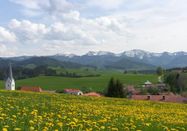
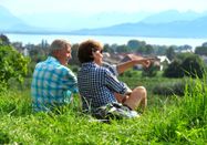
Along the north side, we reach the pedestrian and cycle path, which we join by turning left. At the intersection with Martinstraße, we briefly climb right, then immediately left. We cross the small hill, turn at the public utilities into the forest, and immediately stand at the shore of the idyllic Waldsee. Our path leads past Hotel Waldsee and the outdoor pool, taking us on a beautiful forest and meadow path to Allmannsried.At the northwest village edge, keeping slightly to the right, we continue. At Hof Rappenfluh, the path leads into the forest. After 10 minutes, we look over the large meadow area down to the sparkling Lake Constance and the mighty Alpstein with the main peaks Säntis and Altmann.
Pilgrim stamps:Catholic parish office, Goethestr. 4Tourist Information Lindenberg, Stadtplatz 1
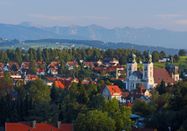
Kinberg - Niederstaufen - Schlachters - Weißensberger Halde - StreitelsfingenAfter the farm named “Kinberg,” we turn right towards the forest. In the forest, we take a steep footpath going down to the left after 80 m, reinforced with stairs. We join a wide forest path, which we follow to the left. After 400 m, we reach a fork. Here, we walk right along a meadow. Steeply downhill, we reach the hamlet of Adelberg. On the paved road, we continue downhill. Shortly before Niederstaufen, we turn left into a small wood and then walk along the forest edge towards Niederstaufen church. We leave it to the left and walk right along Allgäustraße. Passing a grocery store, we reach a junction turning left towards the Leiblach stream.Here we join the Leiblach hiking trail, also called the “Leiblach-Uferweg” on a signpost. We follow downstream. We cross the stream on a narrow steel bridge. On the other bank, we follow a paved path uphill for 400 m, then turn left into the forest section. On a romantic forest and meadow path, the Leiblach hiking trail leads us south. Later, a narrow path returns to the river. Here a bridge leads us over a brook at its confluence with the Leiblach. Now we come to a wider forest path following the river course.
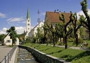
Route through a ravine and Sigmarszell(scenic but challenging)We now cross the B 308 (a tunnel is soon to be built) and follow the path straight to the houses of Dornach. Shortly after the village, we follow the right curve. We reach more houses of the village Dornach. Here we first go right. After 150 m, we go left, following the hiking trail marking of the Leiblach hiking trail, onto a narrow meadow path leading us through a forest ravine with several stairs and a bridge to Sigmarszell. Note: the path through the ravine is unpaved and dangerous when wet.We arrive directly at the church. From here, we turn right and follow the straight road uphill to Biesings. Before rising to the B 308, we turn left and walk 300 m along the roadside until an underpass lets us through to reach Schlachters.
Easier variant along the B308After crossing B 308, we hike 2 km along a bike/hiking path next to the B 308 to Biesings. We cross a side road until an underpass under the B 308 lets us reach Schlachters.
Further from SchlachtersWe walk along the main street past the town hall, turn left shortly before the pharmacy into Weiherstraße. This street leads us into the forest, past the sports field and Schlachters pond. On a bridge, we cross the A 96 and immediately turn right onto a forest path. This takes us in a left curve near the railway tracks. Here we turn left and hike slightly uphill to Weißensberger Halde. This small ascent is rewarded with a wonderful view of Lake Constance and the Alps. At the free-standing chapel, a panorama board helps us identify the names and heights of visible mountains. From the hill, we descend a narrow footpath with a railing. Downhill, we reach a narrow paved footpath, which we follow to the left. It merges into the connecting road, which we take downhill to the right. At the next junction, we pass under B 308 turning left, then turn right at the fork towards Streitelsfingen. From this road, after 500 m, we turn right and follow this path to Streitelsfingen.Pilgrim stamp:Sigmarszell-Schlachters Town Hall, Hauptstraße 28
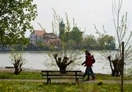
Streitelsfingen - Lindau islandIn Streitelsfingen, we walk past the Montfort Castle on the street. After about 100 meters, we turn left into a meadow path, which leads us steadily on height through orchards. At the end of the meadow path, we descend right and reach Röntgenstraße, which we follow. We reach a residential area. First past the intersections Bäuerlinshalde, Bantingstraße, and Otto-Hahn-Straße, we turn right into a narrow meadow path. We follow this path north of the former Steigbrauerei to Oberreutiner Weg. We leave the cemetery and St. Verena church to the left. The path leads slightly downhill to the left, then easily overlooked, turns left again into a narrow footpath called "das Gängle." Soon we reach Köchlinstraße, which we follow turning right. The street soon makes a sharp left turn. We continue straight past the Sparkasse until we reach Kemptener Straße, which we cross with great caution. On the other side, we reach Bleicheweg by the scenic Köchlinweiher. Along a stream, we reach a nursery, which we leave to the right. Past the construction yard (left), we go straight and cross Bleicheweg at the junction with Privatweg. Past the Sparkasse building, we reach a pedestrian traffic light where we cross the heavily trafficked Bregenzer Straße. After the light, we keep right, pass the barrier of the Lindau–Bregenz railway line and follow Bregenzer Straße further towards the island. After a bridge over the Ach river, we turn left into the town hall area. At the parking lot, we go to the lake. We follow the lakeside path on the right to the pier, which we cross. After the bridge, we immediately turn left again and follow the lakeside path past the casino. After a boat landing, we continue by the lake and then turn right again at the end of the lakeside path until we reach Fischergasse, which we briefly follow past the “Alte Post” turning left. A narrow passage marks the entrance left to Gerberschanze. Here begins another section of the lakeside path, which we follow past the sailing harbor to Lindau harbor.Continuing from the Lindau pier to WasserburgAfter visiting Lindau island, we turn west at the Lindau pier on the land side. First, we pass the mini-golf course along the lake. Then we follow the Aeschacher Ufer to the railway barrier, which we cross. We continue straight on a combined pedestrian and cycle path along the shore and then on Giebelbachstraße to Schachener Straße. Here, we turn left and follow the road, then turn left again after about 500 meters into Oeschländerweg. Soon, signs point left towards Hotel Bad Schachen. Past the impressive hotel complex, the path leads to Lindenhofpark, which we cross a little along the lake. Past Lindenhofbad, we reach Lindenhofweg. In front of Schloss Alwind (a guest home), we go left downhill to the lake. After passing the well-maintained gardens of the castle-like building near the shore, the path leads right uphill again to Uli-Wieland-Straße and soon to Reutener Straße.Pilgrim stamp:Lindau Tourist Information, Alfred-Nobel-Platz 1, opposite the main station
Wasserburg - Reutenen - NonnenhornComing from Lindau, we reach Wasserburg at the town sign (district: Reutenen) on Uli-Wieland-Straße. We follow it to the junction with Reutener Straße. Here, we look to the right at the gable of the small Jakobus chapel, which pilgrims should definitely visit. Our path leads left through meadows to a wayside shrine, where we keep left on the unpaved hiking trail. It brings us back to Reutener Straße and past the outdoor facilities of the swimming pool. Immediately after, we turn left again clearly visible at the entrance area to Sumser-Halle. Now we cross a park-like area with a monument of the “Lieben Augustin” at the lake shore, the playground, and tennis courts. At the first houses, we reach Uferstraße, which we follow until it meets Halbinselstraße. We walk along this to a fork near Hotel "Zum Lieben Augustin." From here, the path leads left to the sights on the Wasserburg peninsula.We keep right, pass the restaurant “Hege Strand 3” and the mini-golf course, and enter a poplar avenue. We stay on this path reserved for walkers and cyclists near the shore, leave a nature reserve on the left, and soon see the Nonnenhorn town sign.Pilgrim stamp:Office parish St. Georg, out of hours by appointment with the pastor
NonnenhornComing from the Wasserburg peninsula, we reach the Nonnenhorn town sign after the beautiful poplar avenue. At the fork, we keep left, along the street by the lake, and make a small detour to the “Malerwinkel,” a public lake access point, where we again enjoy a wonderful view across to the peninsula with Wasserburg castle and St. George’s church. Back on Wasserburgstraße, we follow it and reach after about 1.5 km the 400-year-old “Weintorkel” in the center of Nonnenhorn, which is a must-see. From there, we turn left again towards the lake. The path leads past the tourist information on the right and the boat landing on the left, to the beach and then goes uphill 150 m after a right curve to the Weinstube Fürst. There, we sharply turn right to the historic chapel square and stand before the entrance of St. Jakobus Chapel from the 14th century. Next to its entrance on the right is an overview board of the Jakobusweg in Bavarian Swabia. On the wall of the guesthouse opposite the chapel, we find an old inn sign with St. James.From Wasserburg or Lindau, it is now possible to take the ship to Rorschach and continue on the Swiss Way to Einsiedeln (Lake Constance shipping: May to September!). There is also the option to hike to Friedrichshafen and cross over to Konstanz by catamaran.Pilgrim stamps:Guesthouse Zur Kapelle, next to St. Jakobus Chapel, Tel. 08382-8274Nonnenhorn Tourist Information, Seehalde 2, Tel. 08382-8250Bruno Markowski, Im Gehren 6b, Tel. 08382-8085
You can download the complete brochure with pilgrim-friendly accommodations here: https://www.westallgaeu.de/touren-jakobsweg
Your local tourist information:
Stiefenhofen Guest OfficeHauptstraße 788167 StiefenhofenTel. 08383-7200, Fax 08383-921302gaesteamt@stiefenhofen.de, www.stiefenhofen.de
Weiler-Simmerberg-Ellhofen Tourist InformationHauptstraße 1488171 Weiler im AllgäuTel. 08387-39150, Fax 08387-39153info@weiler-tourismus.de, www.weiler-tourismus.de
Lindenberg Tourist InformationStadtplatz 188161 LindenbergTel. 08381-80328, Fax 08381-80388touristinformation@lindenberg.de, www.lindenberg.de
Sigmarszell-Schlachters Town HallHauptstraße 2888138 SigmarszellTel. 08389-920317, Fax 08389-920349gemeinde@sigmarszell.dewww.sigmarszell.de
Lindau Tourism and Marketing GmbHAlfred-Nobel-Platz 188131 Lindau (Lake Constance)Tel. 08382-8899900, Fax 08382-8899888info@lindau-tourismus.de, www.lindau.de
Wasserburg Tourist InformationLindenplatz 188142 Wasserburg (Lake Constance)Tel. 08382-887474, Fax. 08382-89042tourist-info@wasserburg-bodensee.de, www.wasserburg-bodensee.de
Nonnenhorn Tourist InformationSeehalde 288149 NonnenhornTel. 08382-8250, Fax 08382-89076tourist-info@ti-nonnenhorn.de, www.nonnenhorn.de

Schlechtes Wetter?
Auch bei diesen Bedingungen gibt es viel zu entdecken! Wir haben einige Orte in der Nähe für Sie zusammengestellt, die Sie bei schlechtem Wetter gut besuchen können.
jetzt entdecken