I am an AI and create your individual experience - answer the following questions:
- Duration
- 3:45 h
- Distance
- 10.03 km
- Elevation gain
- 684 hm
Starting point: Trailhead parking lot in Achtal
End point: Trailhead parking lot in Achtal
This scenic hike takes you to the 1,685-meter-high summit of the Schönkahlers and offers a wonderful mix of forest paths and open mountain meadows.
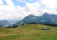
The route starts at the trailhead parking lot in Achtal. At first, you walk leisurely over gravel paths and picturesque forest trails that gently ascend the mountain. Soon the forests open up, giving way to views of the wide, green meadows of the Schönkahlers. The final section runs through an open, hilly landscape that provides a first impression of the impressive mountain scenery.
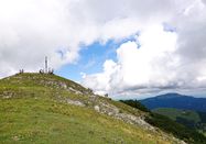
After 2 hours and 20 minutes, you reach the summit, where at 1,685 meters you are rewarded with a fantastic view. The one-way trail includes an ascent of 684 vertical meters. Plan about 4 hours and 40 minutes for the entire round trip.
This hike is ideal for nature lovers seeking a varied route with beautiful views.
Bring a snack with you! There are no opportunities to stop for food along the way.
At the start of the hike is a trailhead parking lot.

Schlechtes Wetter?
Auch bei diesen Bedingungen gibt es viel zu entdecken! Wir haben einige Orte in der Nähe für Sie zusammengestellt, die Sie bei schlechtem Wetter gut besuchen können.
jetzt entdecken