I am an AI and create your individual experience - answer the following questions:
- Duration
- 139:45 h
- Distance
- 387.05 km
- Elevation gain
- 18786 hm
Starting point: Halblech
End point: Pfronten
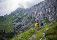
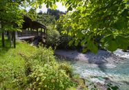
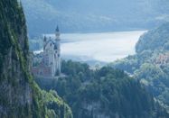
The Himmelsstürmer Route starts in Halblech. From Kenzenhütte, it goes to Tegelberg, then past Neuschwanstein Castle and on to Füssen. From there over Zirmgrat to Pfronten, to Alpspitz in Nesselwang, and then to Oy-Mittelberg. After Rettenberg, Grünten—the guardian of the Allgäu—is climbed. From there, the path leads to Burgberg. Then it continues past Sonthofen and Blaichach over Alpe Gund to Immenstadt. From there, the route—with the possibility of a detour to Missen-Wilhams—heads to Oberstaufen. There, the route goes over Hochgrat to Balderschwang. It continues over Grasgehren and past Bolsterlang to Ofterschwang up to Fischen—the so-called Hörner villages. Then it follows along the Iller to Oberstdorf, through Oytal and high up to Nebelhorn. Past Engeratsgundsee, it goes to Bad Hindeland. Then the route goes to Austria into the Tannheimer Tal, which is completely crossed via Schattwald, Tannheim and Grän. After Kissinger Hütte follows Breitenberghütte before descending into the valley to Pfronten.
- Halblech: Birdwatching station
- Füssen: Lute museum
- Pfronten: Falkenstein ruin
- Nesselwang: Alpspitzkick
- Oy-Mittelberg: Primavera
- Rettenberg: Mug museum
- Burgberg: Ore mines
- Sonthofen: Starzlach gorge
- Blaichach: Herb garden in Gunzesried
- Immenstadt/Bühl: Nature park house
- Oberstaufen: Golfing
- Balderschwang: 2000-year-old yew
- Fischen: Cattle drive
- Oberstdorf: Mountain exhibition
- Bad Hindelang: Tractor rides in Oberjoch
- Tannheimer Tal: Local history museum
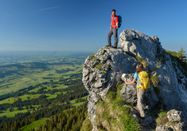
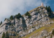
The hike on the Himmelsstürmer Route begins at the Kenzenhütte parking lot at the edge of the town of Halblech and follows together with the Wasserläufer Route coming from Lechbruck am See to Oberstaufen. In Oberstaufen, the routes split; for the Himmelsstürmer, alpine hiking through mountain landscapes now begins. But even the first stage provides a foretaste of the mountain experience: almost 700 meters of elevation gain must be mastered. Passing by some small reservoirs and the idyllic Wankerfleck, the Kenzenhütte at almost 1,300 m is the best place to rest and enjoy. Then it’s on to the Tegelberghaus, the goal of the second stage. It’s just 10 km to get there, but with nearly 1,000 meters of ascent, it’s challenging. Rushing is, of course, out of place; one hikes slowly and steadily through alpine terrain with repeatedly spectacular views. The third stage is also full of views. The destination Füssen is 11.5 km away and over 1,200 meters downhill. Packed with Marienbrücke, Pöllatschlucht, the royal castles, Kalvarienberg, and naturally the resounding Füssen, this stage offers an incomparable wealth of impressions. The fourth stage begins with a walk through the old town of Füssen and continues forest-rich above the town. The Alatsee is enchanting, somewhat mystical, and ideal for swimming. A technically easy but tough climb leads up to Salober Alm and thus to Austria. Past the ruins of Falkenstein Castle begins the descent through the forest. Meadows and the Vils River await in the valley, companions all the way to Pfronten. Stage five leads from Pfronten to Nesselwang with just under 11 km. The elevation gain and loss are almost equal at over 600 m; in between lies the top station of the Alpspitzbahn at 1,445 m. You can already make a detour to the nearby Alpspitze. The descent to Nesselwang can alternatively be done by chairlift, making for a relaxed start to the sixth stage. The roughly 14 km hike to Oy-Mittelberg goes over the Alpsitze. Forest and meadows alternate continuously, the Grüntensee and pleasant scents at the stage destination: always follow your nose! The seventh stage goes to the roughly 24 km distant Rettenberg. Variety is guaranteed: forest, scenic heights, villages, and repeatedly path tracks over pasture areas up to the guardian of the Allgäu, who plays the main role in the eighth stage. Guardian of the Allgäu is the over 1,700 m high Grünten. Over 1,000 m up, over 1,000 m down, with a view in between that is unmatched. And shortly before Burgberg, the wildly romantic Starzlachklamm surprises! For the ninth stage, you have the choice: from Burgberg a) via Steineberg to Alpe Gund, b) to Sonthofen, or c) to Gunzesried. Alpe Gund is a day tour with over 1,000 meters of ascent. To Sonthofen, just a roughly two-hour walk. Gunzesried lies almost on the way to Alpe Gund and is feasible as a detour. Otherwise, as so often: less is more. On the 10th stage from Alpe Gund to Bühl am Alpsee, it goes only downhill, so after about 2 ½ hours, you can refresh yourself in the lake. If that’s too little hiking, you can choose the variant to Missen-Wilhams. The 11th stage is again a perfect mix of forests, wide meadows, and ridges dotted with Alps. Arriving in Oberstaufen, you have covered nearly 20 km with more than 600 m of elevation gain.
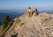
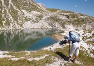
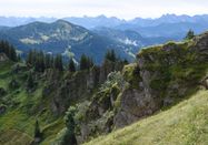
In Oberstaufen, Wasserläufer and Himmelsstürmer routes split. The Wasserläufer Route leads to Oberreute, the Himmelsstürmer Route continues southward heading to Hochgrat. Up to its steep ascent, forests and meadows alternate, some Alps invite for stops, and Weißachtobel as well as Buchenegger Waterfalls provide additional refreshment. After the last rocky ascent—totaling about 1,600 m—the Staufener Haus awaits tired but happy hikers. The 13th stage offers twice as many meters downhill as uphill, nearly 1,200 m. Near Heidekopf, a somewhat more demanding rock passage delights; then you descend over Girenkopf to Balderschwang. After starting in Balderschwang, the next ascent comes quickly. On the way to the stage destination Grasgehren, several summits and a pass are crossed. The most fascinating may be crossing a raised bog. Several Alps invite visits in between, so the nearly 1,100 meters of climb might go unnoticed. On the 15th stage to Fischen, there is clearly more downhill than uphill. Like pearls strung together, Riedberger Horn, Großer Ochsenkopf, Weiherkopf, Rangiswanger Horn, and Ofterschwanger Horn await Himmelsstürmer hikers. At the last of the “horns,” there is a trilogy ladder leading to Alpe Gund, with ascent and descent roughly balanced at about 1,400 m each time. The main route leads downhill to Ofterschwang and then mostly flat to Fischen. Compared to preceding stages, the 16th is for relaxed hiking. Just 13 km and slightly over 300 meters ascent, leaving plenty of time to explore Oberstdorf, for example visiting the ski jump. Or simply resting, as the ascent to Edmund-Probst-Haus requires some rocky sections to be passed cautiously and exactly 1,300 m to be covered. Those wanting a recommended trip to Nebelhorn can add another 300 meters of ascent. The 18th stage to Schwarzenberghütte is very short at just eight kilometers but wonderfully beautiful. Without much elevation gain, magnificent mountain panoramas can be enjoyed from the rocky path that passes small lakes. Snowfields can still be expected here in midsummer. From Engeratsgrundsee, a side path leads to the stage goal about 800 m lower. The next stage begins as the previous one ended—with an ascent to Engeratsgrundsee. From the nearby saddle, it goes about 1,000 meters steadily downhill into Hintersteiner Tal. Lush meadows and the river Ostrach are pleasant companions at the end of the 19th stage. The next stage begins with a walk through the Bad Hindelang spa park. Past Schleierfall, the ascent continues to the Iselerbahn top station. A constant alternation of forest, meadow, and scree fields appears along Schmugglersteig down to the Austrian Schattwald in the Tannheimer Tal, which on the comfortable 20th stage is hiked to the nearby town of Tannwald. The 21st stage continues first in the valley to the village of Grän, where the ascent to Füssen Jöchl begins. Passing Sebeneralm (no food stop possible), you follow a panoramic trail continuously to Bad Kissinger Hütte. From there, it goes past the scenic summit Aggenstein to Ostler Hütte on Breitenberg. Initially along a ridge trail, then down the forest in numerous hairpin bends. Upon reaching the valley, about 1,300 meters of descent are behind you. Past Fallmühle, it is not far to the start and welcome point of Pfronten.
The following overview is intended to give you orientation to use public transport (ÖPNV) effectively:
www.zum-kempten.de: Kempten, Durach, Oy-Mittelberg, Petersthal
www.rba-bus.de, www.rvo-bus.de: Halblech, Lechbruck, Füssen, Schwangau, Pfronten, Nesselwang, Kaufbeuren, Marktoberdorf
www.oberallgaeu.org: Petersthal, Burgberg, Rettenberg, Immenstadt, Missen-Wilhams, Oberstaufen, Oberreute, Bad Hindelang, Fischen, Sonthofen, Blaichach, Fischen
www.rba-bus.de: Lindenberg, Scheidegg, Weiler-Simmerberg, Oberreute, Oberstaufen

Schlechtes Wetter?
Auch bei diesen Bedingungen gibt es viel zu entdecken! Wir haben einige Orte in der Nähe für Sie zusammengestellt, die Sie bei schlechtem Wetter gut besuchen können.
jetzt entdecken